Distance between two points, midpoint (up to 3d), angle between two lines: notes and practice questions
- 2D Distance between points and :
- 2D Midpoint of points and :
- 2D Gradient of a line segment:
- 3D Distance between points and :
- 3D Midpoint of points and :
- Angle between two lines with direction vectors and (HL):
- To find the acute angle between two lines (HL):
- Ensure GDC is in the correct angle mode (degrees or radians) for inverse cosine calculations.
How it is examined
A reliable early question on both SL papers, usually a composite solid where the student finds a volume, then a surface area, then an angle. Because the formulas are in the booklet, the marks are for picking the right solid, decomposing the shape, and identifying the right-angled triangle inside it. The restriction to right-angled trigonometry in 3D at SL is the line to hold when writing questions.
The distance between two points in three dimensions, the coordinates of the midpoint, and the volume and surface area formulas for the right-pyramid, right cone, sphere and hemisphere. This is a real difference from AA, where students recall more of these.
- The distance between two points in three-dimensional space, and their midpoint.
- The volume and surface area of three-dimensional solids including the right-pyramid, right cone, sphere, hemisphere, and combinations of these solids.
- The size of an angle between two intersecting lines, or between a line and a plane.
Linking questions
- Other contexts: architecture and design.
- Links to other subjects: design technology; volumes of stars and the inverse square law (physics).
- TOK: what is an axiomatic system? Are axioms self evident to everybody?
Practice questions
38 questions · 28 medium · 10 hardQuestion 1
MediumPaper 1 · calculator10 marksA high-tech drone is launched from a control tower at coordinates (1.5, 2.0, 0.8) relative to the base of the tower at the origin O. The x direction is due east, the y direction is due north, and the z direction is vertically upwards.
All distances are measured in kilometres.
The drone travels with a constant velocity, and its direction of travel is given by the vector .
Assuming the drone travels in a straight line, write down an equation for the line along which it travels.
The drone is programmed to land on a designated pad at ground level (where ).
(i) Find the value of the parameter when the drone reaches ground level.
The drone is programmed to land on a designated pad at ground level (where ).
(ii) Determine the coordinates of the landing pad.
Calculate the distance the drone travels from its initial position to the landing pad.
Recall the general form of a vector equation of a line: , where is a position vector of a point on the line and is the direction vector.
The z-component of the drone's position vector must be equal to the ground level. Set the z-component of your line equation to 0 and solve for .
Substitute the value of found in part (b.i) back into the vector equation of the line to find the coordinates of the landing pad.
Find the displacement vector from the initial position to the landing pad, then calculate its magnitude. The distance formula is .
Question 2
HardPaper 1 · calculator9 marksThree emergency service hubs are located at coordinates F1 (2, 5), P1 (10, 5), and H1 (10, 15), where distances are measured in kilometers. A central dispatch unit needs to be built at a location equidistant from these three hubs. This location is a vertex of the Voronoi diagram formed by the hubs.
Write down the coordinates of this central dispatch unit.
Find the equation of the perpendicular bisector of the segment connecting F1 (2, 5) and H1 (10, 15).
A new emergency hub, S1 (4, 8), is established, and the Voronoi diagram is redrawn. Several potential locations for a new drone charging station are at the vertices of this updated diagram. The coordinates of four such vertices are given as V_alpha (6, 10), V_beta (6, 4.5), V_gamma (8.75, 10), and V_delta (, ). The drone charging station should be built at the vertex that is as far as possible from its nearest emergency service hub.
By calculating appropriate distances, find the location of the drone charging station.
Hence, write down the distance of the drone charging station to the nearest emergency service hub.
The central dispatch unit is the circumcenter of the triangle formed by F1, P1, and H1. Consider the perpendicular bisectors of the segments connecting the hubs.
First, find the midpoint of the segment [F1H1]. Then, calculate the gradient of [F1H1] and its negative reciprocal to find the gradient of the perpendicular bisector. Finally, use the point-gradient form of a straight line.
For each given vertex, calculate its distance to all four hubs (F1, P1, H1, S1). Identify the shortest distance for each vertex. Then, choose the vertex for which this shortest distance is the largest.
Refer to your calculations in part (c.i) for the maximum of the minimum distances.
Question 3
MediumPaper 1 · calculator5 marksA team of geologists is mapping underground rock formations using a 3D coordinate system. The x and y axes represent horizontal distances across the surface, and the z-axis represents depth below the surface (with positive z indicating deeper). However, for this particular survey, the z-axis is set to represent altitude above a reference point, so positive z means higher.
Two key geological markers, P and Q, have been identified. Marker P is located at coordinates (100, 20, 50) and Marker Q is at (40, 60, 290). All coordinates are given in metres.
(a) Find the straight-line distance between Marker P and Marker Q.
A new sensor, S, is to be installed exactly halfway between Marker P and Marker Q.
(b) Find the coordinates of the sensor S.
(c) Write down the altitude of the sensor S, in metres, above the reference point.
Recall the 3D distance formula: .
The midpoint formula for 3D coordinates is .
The altitude corresponds to the z-coordinate.
Question 4
HardPaper 1 · calculator8 marksA botanical garden features a winding path for visitors. The path can be modelled by the function . All distances in the garden are in kilometres.
A new straight maintenance path needs to be constructed. This path will start at point P on the visitor path, which has coordinates .
(a) Using your graphic display calculator, find the value of .
(b) Find the equation of the line normal to at point P.
(c) The maintenance path connects point P to another point Q on the visitor path, where the normal line intersects the path again. For safety regulations, point Q must have a positive x-coordinate. Determine the length of this new maintenance path.
Remember how to use the derivative function on your GDC for a specific point. You are looking for the gradient of the tangent at .
The gradient of the normal line is the negative reciprocal of the gradient of the tangent line at that point. Use the point-gradient form of a straight line equation.
First, find the coordinates of point Q by setting the equation of the normal line equal to the function and solving for using your GDC. Remember that P is one of the intersection points. Then, use the distance formula between P and Q.
Question 5
MediumPaper 1 · calculator4 marksA drone takes off from a launch pad located at the origin O(0, 0, 0) of a coordinate system. It flies in a straight line to a target destination T with coordinates (5.0, 3.0, 7.0). All units are in metres.
(a) Calculate the total distance the drone travels from the launch pad to the target.
(b) Determine the angle of elevation of the drone's flight path from the horizontal ground.
Recall the distance formula in three dimensions, or consider the magnitude of the displacement vector from O to T.
Consider the right-angled triangle formed by the drone's height, its horizontal displacement, and its flight path. The horizontal displacement is the distance from the origin to the point (5.0, 3.0, 0).
Question 6
HardPaper 1 · calculator12 marksA drone is used for aerial surveying. It starts at a central hub (H).
(a)(i) From H, it flies 15 km on a bearing of 040° to survey point S1. From S1, it flies 10 km on a bearing of 170° to survey point S2.
Determine the interior angle HS1S2.
(a)(ii) Determine the distance from S2 back to H.
(a)(iii) Determine the bearing the drone must use to travel directly from S2 to H.
(b) The drone's mission also includes a final delivery point D, such that S1S2DH forms a parallelogram. Write down the distance between point D and point H. Justify your answer.
Draw a diagram with North lines at H and S1. Use the given bearings and properties of parallel lines (North lines) to find the internal angle at S1.
You have two sides of triangle HS1S2 (HS1 = 15 km, S1S2 = 10 km) and the included angle (HS1S2 = 130°). Use the cosine rule to find the third side.
First, use the sine rule to find angle HS2S1 in triangle HS1S2. Then, consider the back bearing from S2 to S1 and use the calculated angle to find the bearing from S2 to H.
Recall the properties of a parallelogram, specifically regarding opposite sides.
Question 7
MediumPaper 1 · calculator7 marksTwo historical landmarks are located at points A(4, 10) and B(16, 2) on a coordinate map. A proposed new scenic path, represented by the line R with equation , passes near these landmarks. A new visitor centre is to be built on this scenic path such that it is equidistant from both landmarks.
(a) Find the equation of the perpendicular bisector of the line segment [AB]. Give your equation in the form .
(b) Determine the coordinates of the point on the scenic path R where the visitor centre should be located.
First, calculate the gradient and midpoint of the line segment [AB]. Then, use the negative reciprocal of the gradient to find the gradient of the perpendicular bisector. Finally, use the midpoint and the perpendicular gradient to form the equation of the line.
The visitor centre is at the intersection of the perpendicular bisector (found in part a) and the scenic path R. Solve the two equations simultaneously.
Question 8
HardPaper 2 · calculator19 marks(a) A space probe, 'Voyager Alpha', is launched from a space station. The position of the probe at time days after launch is given by the vector
Distances are measured in thousands of kilometres.
Find the position vector of the probe days after launch.
(b) A second space probe, 'Explorer Beta', is launched from a different station. The position vector of this probe is given by the vector
Determine if the two flight paths intersect and, if so, state the point of intersection.
(c) The two probes were launched at the same time, so .
State, with a reason, whether the two probes actually collide.
(d) Calculate the distance between the two space stations (the initial launch points).
(e) Calculate the shortest distance that ever exists between the two probes and the time when this occurs. Assume days.
Substitute the given time value into the vector equation for the probe's position.
Equate the components of the two position vectors to form a system of linear equations. Solve for and using two of the equations, then check if these values satisfy the third equation.
Consider the results from part (b). For a collision to occur, the paths must intersect AND the probes must be at the intersection point at the same time.
The initial launch points are the constant vectors in the position equations (when or ). Use the 3D distance formula.
Form a vector representing the difference in position of the two probes at time (since they launched simultaneously, ). Find the magnitude squared of this difference vector, then differentiate with respect to and set to zero to find the minimum. Remember to consider the domain .
Question 9
MediumPaper 1 · calculator9 marksA surveillance drone D is flying with a constant velocity, , measured in kilometres per hour, where
.
At time the drone is at a point A(50, 20) relative to an origin O, where distances are
measured in kilometres.
Find the position vector of the drone at time hours.
A protected bird's nest is located at a point N(99, 2).
Find the value of when the drone will be closest to the bird's nest.
An environmental sensor will trigger if the drone flies within 18 kilometres of the nest.
State whether the sensor will trigger. Give a reason for your answer.
Recall that the position vector of an object moving with constant velocity is given by , where is the initial position vector and is the velocity vector.
The drone is closest to the nest when the vector connecting the nest to the drone is perpendicular to the drone's velocity vector. This means their dot product is zero.
Calculate the minimum distance between the drone and the nest using the value of found in part (b), then compare it to the given trigger distance.
Question 10
HardPaper 2 · calculator13 marks(a) The position of a reconnaissance drone, relative to a control tower, is given by the vector equation , where is the position vector in metres and is the time in minutes.
Write down the position vector of the drone when and when .
(b) Calculate the speed of the drone.
(c) Find an expression for the distance of the drone from the origin at time .
(d) Hence find the minimum distance of the drone from the origin and the time at which it occurs.
Substitute the given values of into the vector equation to find the corresponding position vectors.
The velocity vector is the direction vector in the position equation. The speed is the magnitude of the velocity vector.
First, write the position vector in terms of its components at time . Then, use the distance formula from the origin, which is the magnitude of the position vector.
To minimize the distance, you can minimize the square of the distance. This will result in a quadratic function. You can find the minimum of a quadratic function by taking its derivative and setting it to zero, or by using the formula for the vertex of a parabola.
Question 11
MediumPaper 1 · calculator5 marksThree environmental sensor stations are located at S1(15, 40), S2(5, 25), and S3(30, 30) according to a local coordinate system, where distances are measured in kilometers.
A new construction site is planned at position C(22, 35).
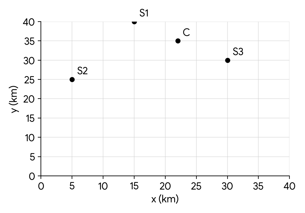
Find the distance between the construction site C and sensor station S1.
On a particular day, the mean PM2.5 levels recorded at sensor stations S1, S2, and S3 are 28 g/m, 35 g/m, and 20 g/m respectively.
Use nearest neighbour interpolation to estimate the PM2.5 level at the construction site C on that particular day.
Recall the distance formula between two points and which is .
First, calculate the distance from the construction site C to each of the sensor stations S1, S2, and S3. Then, identify which station is closest to C. The PM2.5 level at the closest station will be your estimate.
Question 12
HardPaper 2 · calculator14 marksA drone A takes off from a control tower at 10:00. It flies north-east at a horizontal speed of and climbs at a rate of . At 10:00, it is at a height of directly above the control tower.
Find an expression for the displacement of drone A from the control tower at time hours after 10:00. Assume the control tower is at the origin (0,0,0) and the positive y-axis points North, and the positive x-axis points East.
At 10:30, a second drone B is directly above the control tower. It flies on a bearing of at a horizontal speed of and descends at a rate of .
Find an expression for the displacement of drone B from the control tower hours after 10:00.
Find the distance the two drones are apart when they have the same height.
Start by defining the initial position vector and the velocity vector of drone A. Remember that North-East implies equal components in the x and y directions for the horizontal velocity.
Remember that drone B starts its motion at 10:30, so its time variable will be different from . Bearings are measured clockwise from North (positive y-axis).
First, equate the z-components of the displacement vectors from parts (a) and (b) to find the time when their heights are equal. Then, substitute this time back into both displacement vectors to find their positions, and finally calculate the distance between these two points.
Question 13
MediumPaper 1 · calculator7 marksRelative to a central command station, two space probes, P and Q, have positions and respectively, where the units of measurement are in millions of kilometres.
Find the distance between the two space probes.
Determine which of the space probes is closer to the central command station.
Recall the 3D distance formula between two points and : .
The central command station can be considered the origin . Calculate the distance of each probe from the origin and compare.
Question 14
HardPaper 2 · calculator15 marksA geological survey team is setting up sensors in a remote area. A map of the area is represented on the following coordinate axes.
Three sensor locations are positioned at , and .
All measurements are in kilometres.
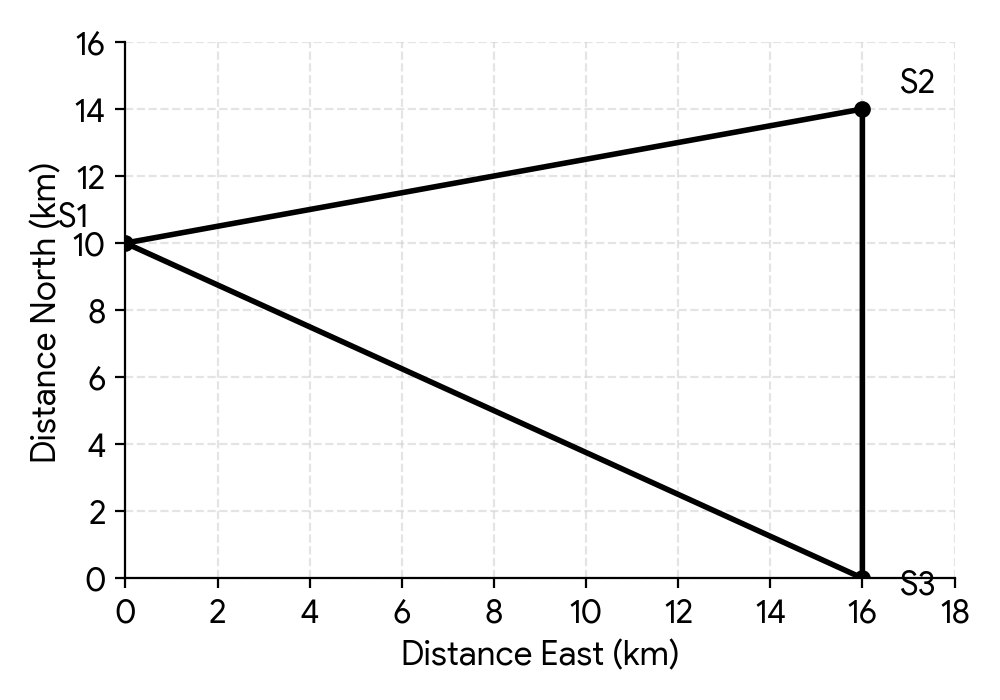
(a) Write down the distance between and .
(b) Calculate the distance between and .
(c) A geological team member is at sensor and needs to walk directly to sensor . Calculate the bearing of from .
A communication relay station is to be installed at a point that is an equal distance from each of the sensors at , , and .
(i) Write down the gradient of the line segment .
(ii) Write down the coordinates of the midpoint of the line segment .
(iii) Hence, calculate the coordinates of the communication relay station.
The distance between two points and can be found using the distance formula . For points on a vertical or horizontal line, this simplifies to the absolute difference in the changing coordinate.
Use the distance formula for the points and . Remember to take the square root of the sum of the squared differences in coordinates.
Bearings are measured clockwise from North. First, determine the change in easting and northing from to . Then, use trigonometry to find the angle relative to the North-South line and convert it to a bearing.
The gradient of a line segment connecting and is given by .
The midpoint of a line segment connecting and is given by .
The communication relay station is equidistant from , , and . This means it is the circumcenter of the triangle formed by these points. The circumcenter is the intersection of the perpendicular bisectors of the sides of the triangle. You already have the gradient and midpoint for . Find the perpendicular bisector for another side, for example , and solve the system of equations.
Question 15
MediumPaper 1 · calculator8 marksA drone is flying between two observation towers. Tower A is located at coordinates and Tower B is located at coordinates . The drone's flight path is a straight line segment AB. The drone needs to refuel at a station located exactly halfway along its flight path.
Find the coordinates of the refueling station.
Let be the line representing the drone's flight path from Tower A to Tower B.
Find the gradient of .
A security laser beam, , is emitted from the refueling station and is designed to be perpendicular to the drone's flight path.
Write down the gradient of .
Find the equation of . Give your answer in the form .
Remember the midpoint formula for two points and .
Recall the formula for the gradient of a line passing through two points.
What is the relationship between the gradients of two perpendicular lines?
Use the gradient found in (c.i) and the coordinates of the refueling station from (a) in the point-gradient form of a line.
Question 16
HardPaper 2 · calculator15 marksA drone delivery service operates from three main hubs, P, Q, and R, whose locations are represented on a coordinate plane. All measurements are in kilometres.
Hub P is at , Hub Q is at , and Hub R is at .
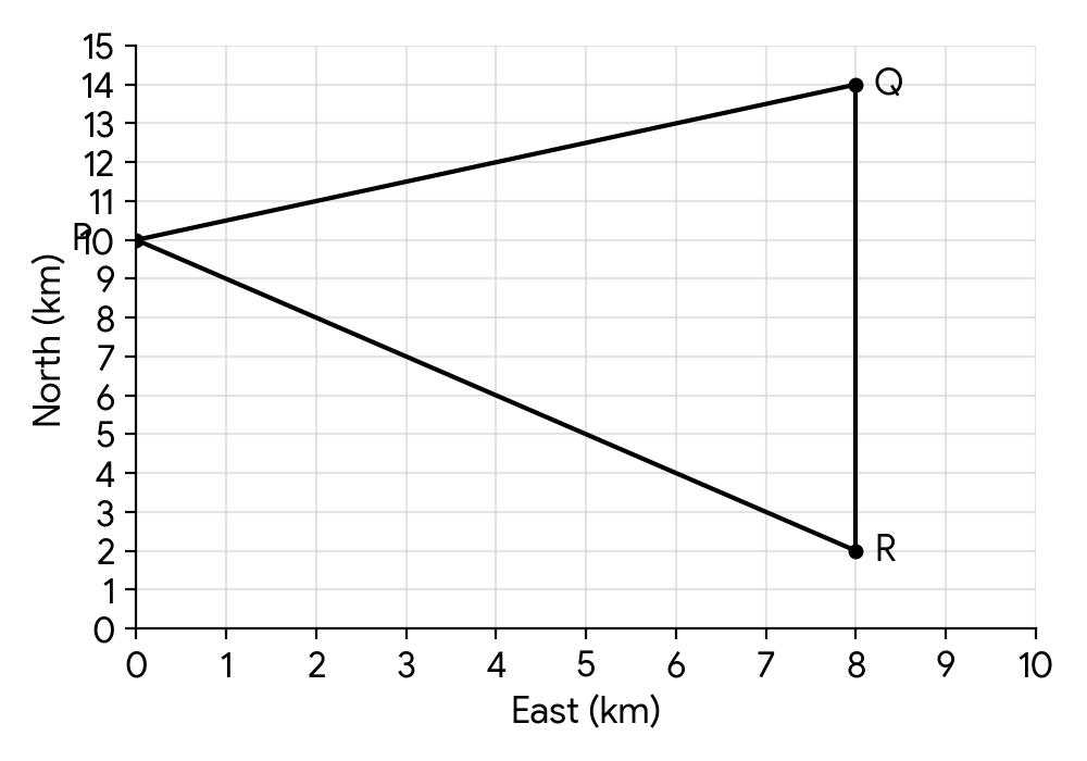
Write down the distance between Hub Q and Hub R.
Calculate the distance between Hub P and Hub Q.
A drone is at Hub Q and needs to fly directly to Hub P. Calculate the bearing of P from Q.
A central charging station is to be built at a location equidistant from Hubs P, Q, and R.
Write down the gradient of the line segment [PR].
Find the coordinates of the midpoint of [PR].
Hence calculate the coordinates of the central charging station.
The hubs Q and R share the same x-coordinate. What does this mean about the line segment connecting them?
Use the distance formula, which is derived from the Pythagorean theorem. Consider the change in x-coordinates and y-coordinates.
First, determine the change in x and y coordinates from Q to P. Then, use trigonometry to find the angle with respect to the North line. Remember bearings are measured clockwise from North and are typically given as three figures.
The gradient of a line segment between two points and is given by .
The midpoint of a line segment between two points and is given by .
The central charging station is the circumcenter of the triangle formed by P, Q, and R. It is the intersection point of the perpendicular bisectors of the sides of the triangle. You'll need the gradient and midpoint of at least two sides to find their perpendicular bisectors.
Question 17
MediumPaper 1 · calculator5 marksA geological survey team is establishing a network of sensor stations in a remote volcanic region. These stations are connected by automated drone routes for data collection. The coordinates of the stations are given in kilometres relative to a central base camp.
The coordinates of the Base Camp (A) are .
Observation Post 1 (B) is located at .
Observation Post 2 (C) is located at .
(a) Determine the distance a drone travels from the Base Camp (A) to Observation Post 1 (B).
(b) For a drone to reach Observation Post 2 (C), it must first travel from the Base Camp (A) to Observation Post 1 (B), and then take a separate route from B to C.
Determine the total distance covered by a drone travelling from the Base Camp (A) to Observation Post 2 (C) via Observation Post 1 (B). Give your answer to three significant figures.
Recall the distance formula in three dimensions: .
First, calculate the distance between B and C. Then, add this to the distance found in part (a). Remember to round your final answer to three significant figures.
Question 18
HardPaper 2 · calculator15 marksThe 'EcoPack' company designs sustainable packaging. They produce a standard closed rectangular storage container with a length of cm, a width of cm, and a height of cm. The information is shown in the diagram.
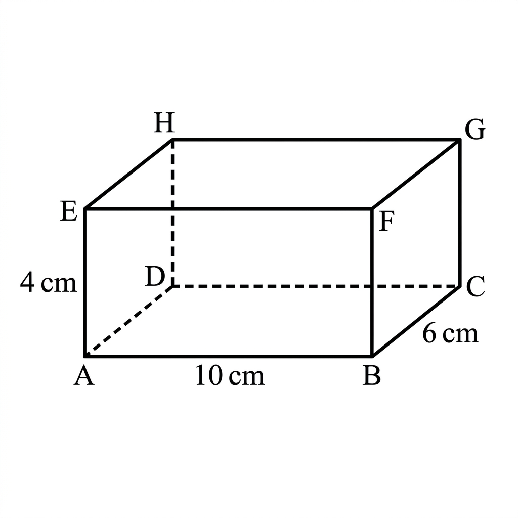
Calculate the surface area of the container in cm.
(b) Calculate the length of the longest internal diagonal of the container.
(c) Each week, EcoPack sells thousand containers. It is known that , for , where is the weekly profit, in dollars, from the sale of thousand containers.
Find the number of containers that should be sold each week to maximize the profit.
(d) The profit from the sale of containers is $2500.
Find .
(e) Find the least number of containers which must be sold each week in order to make a profit.
The surface area of a rectangular prism is given by the formula , where is length, is width, and is height.
The longest internal diagonal of a rectangular prism can be found using the 3D Pythagorean theorem: .
To maximize profit, set the derivative of the profit function, , equal to zero and solve for . Remember that is in thousands of containers.
Integrate the derivative to find . Use the given profit information to find the constant of integration.
To make a profit, must be greater than zero. Find the values of for which and choose the smallest integer value of that results in a profit.
Question 19
MediumPaper 1 · calculator8 marksA remote research station, R, located at coordinates , requires supplies to be dropped off at a point along a straight supply route, S. The supply route S can be modelled by the equation . All coordinates are given in kilometres.
To minimize travel time for the delivery drone, the drop-off point, D, must be the point on the supply route closest to the research station.
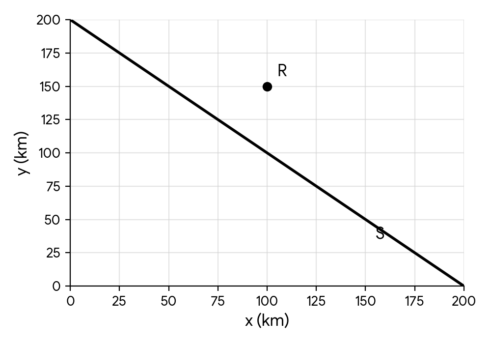
Determine the coordinates of D, the optimal supply drop-off point.
Find the distance between the research station R and the optimal drop-off point D.
The shortest distance from a point to a line is along the line segment that is perpendicular to the given line. Find the equation of this perpendicular line and then its intersection with the supply route.
Use the distance formula with the coordinates of the research station R and the drop-off point D found in part (a).
Question 20
HardPaper 2 · calculator17 marksA deep-sea research submersible, 'Nautilus', is being tracked relative to an underwater research station, 'Triton Base'. The coordinates represent the submersible's displacement in kilometres, where is east, is north, and is vertical displacement (positive upwards, so negative for depths below sea level).
At 10:00 AM, the submersible is detected at a position 60 km east and 24 km north of Triton Base, and at a depth of 15 km below sea level. Its velocity is given as kmh. Let be the length of time in hours from 10:00 AM.
Write down a vector equation for the displacement, , of the submersible in terms of .
If the submersible continued to travel with the given velocity,
verify that it would pass directly over Triton Base (the point );
state the depth of the submersible at this point;
find the time at which it would pass directly over Triton Base.
When the submersible is at a depth of 18 km below sea level, it continues to move horizontally on the same bearing but adjusts its vertical velocity so that it will dock precisely at Triton Base .
Find the time at which the submersible is at a depth of 18 km below sea level.
Find the direct distance of the submersible from Triton Base at this point.
Given that the velocity of the submersible, after the adjustment of the vertical velocity, is kmh, find the value of .
Recall the formula for a position vector given an initial position and a constant velocity: . Ensure all components (x, y, z) are correctly represented, especially the sign for depth.
For the submersible to pass directly over Triton Base, its and coordinates must simultaneously be zero. Set the and components of your vector equation from part (a) to zero and solve for . If the values of are the same, it passes directly over the base.
Use the time found in part (b.i) and substitute it into the -component of the displacement vector to find the depth.
Convert the time in hours from part (b.i) into a clock time, given the starting time of 10:00 AM.
Set the -component of the displacement vector equal to km (since it's 18 km below sea level) and solve for . Then convert this to a clock time.
First, find the full position vector of the submersible at the time found in part (c.i). Then, calculate the magnitude of this position vector to find the direct distance from the origin (Triton Base).
The submersible adjusts its vertical velocity at the time found in part (c.i). From this adjusted point, it needs to reach at the same time its and coordinates reach zero (as it continues on the same horizontal bearing). Calculate the time remaining for the horizontal movement and the required change in over that time to find the new vertical velocity component .
No question on this page matches those filters. Try another difficulty or paper.
18 more Distance between two points, midpoint (up to 3d), angle between two lines questions in the app
Every answer is marked mark by mark, IB-style, and the AI tutor helps when you are stuck.
Where marks are lost
- Leaving an answer in calculator notation. Never accepted in a final answer, and AI's constant calculator use makes this the easiest slip in the whole subject.